
A Guide To Huascaran
Covering a spectacular 3,400 sq km (1,313 sq miles) of high Andean territory, Huascaran National Park is unparalleled anywhere in the Americas.
Within its 180 km (112-mile) length, the park includes all but the two northernmost glaciated mountains of the Cordillera Blanca.
Nearing the top of Vallunaraju Mountain.
Massive Huascaran is the biggest, of course, but at least 20 more exceed the sought-after elevation of 6,000m (19,685ft), making this area extremely popular with mountaineers.
The snow-clad peaks overlook gorgeous lakes and steep-sided quebradas (ravines), along which footpaths enable trekkers to get into the heart of the park. Between the mountain massifs, the trails snake their way over 4,750 m (15,585 ft ) passes which give in-your-face views of impossibly steep ice walls.
The most famous of these trails, and deservedly so, is Punta Union on the four or five-day Santa Cruz trek, from where almost the entire 360-degree horizon is ruled by tongue-twisting behemoths such as Taulliraju (5,830 m / 19,128 ft), Quitaraju (6,036 m / 19,804 feet), Artesonraju (6,025 m / 19,768 feet), and Chacraraju (6,112 m / 20,053 feet). Raju is the Quechua word for “snow peak”, by the way.
A panoramic view from Punta Union pass, on the Santa Cruz trek.
Other popular treks in Huascaran National Park include the Alpamayo Base Camp route (7-12 days) which goes over several high passes and through the remote Quebrada de los Cedros on the north side of Alpamayo.
You can finish in various villages, depending on the length of the trek.
The three-day Olleros to Chavin trek goes over one high pass (4, 700 m / 15,420 ft) and emerges at the archeological site of Chavin de Huantar. Many other options exist.
Both climbers and trekkers find the best time to be in the Cordillera Blanca is the dry season, which begins in mid-May and usually lasts into mid-September. That does not mean you won’t get rained or snowed on, though!
Trekking out of season is certainly possible, if you have good rain gear and well waterproofed tents. The wettest months are from January to March.
If the thought of sleeping in a tent does not appeal to you, there are plenty of day-trip options.
The best known trip is to the Llanganuco Lake, east of Yungay and 80 km (50 miles) from Huaraz.
Tours often stop at the Campo Santo by Yungay, before following the unpaved road up the narrow Quebrada Llanganuco to two lovely mountain lakes at 3,850 m (12,632 ft).
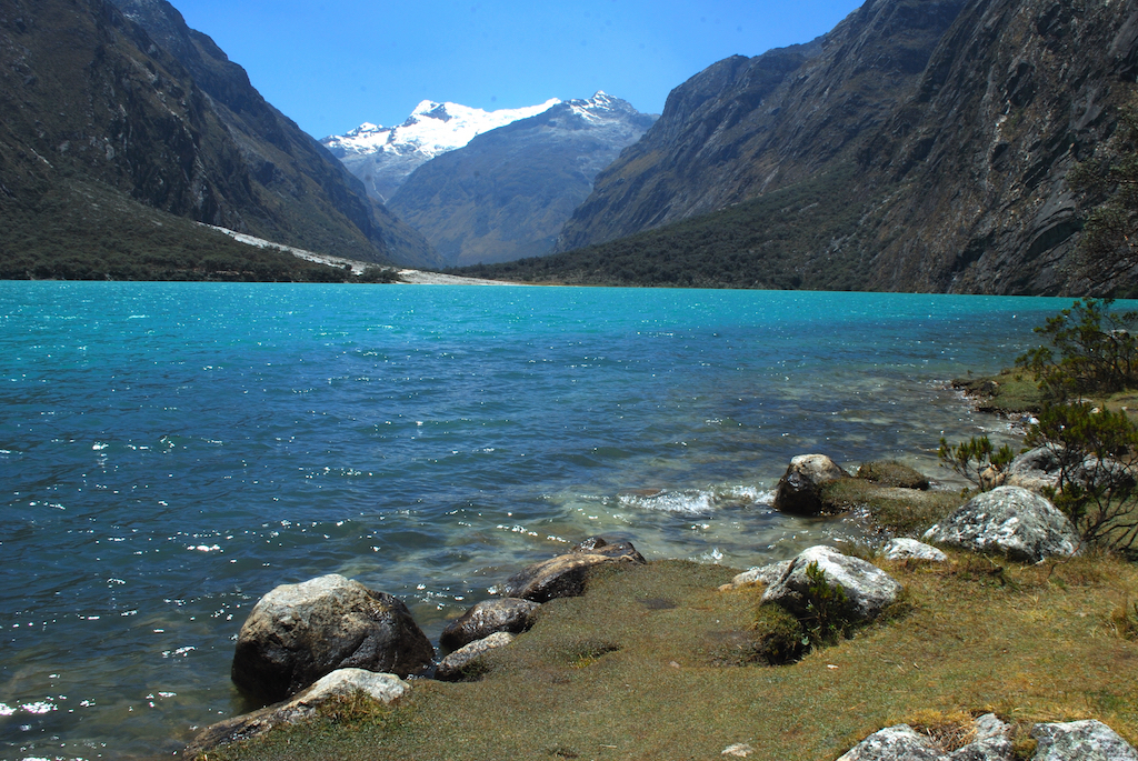
The crystal-blue waters of a Llanganuco lake framed by the mountains of the Cordillera Blanca.
The first lake, Chinancocha (Quechua for “Female Lake”) has a nature trail at its west end (90 minutes hike), and also has rowboats for hire. At its east end is a forest of Polylepis trees (locally called quenuales), recognized by their rust-colored bark which peels off the trunk like sheets of paper. Once a common tree in the Andes, only pockets of this representative highland native species remain. Locals have burned it to clear land for pasture and use it as firewood.
The second lake, Orconcocha (“Male Lake”), is a few meters higher than the first. The lakes lie between Huascaran and triple-peaked Huandoy (6,395 m / 20,982 ft) which spectacularly dominate the view as you drive up.

Snow-capped peak of Huandoy Mountain visible from the Llanganuco Valley.
The road beyond the lakes continues over a high pass, the Portachuelo de Llanganuco (4,767 m / 15,640 ft) and drops through Vaquería, past the hamlet of Colcabamba and on to the village of Yanama 20 km (12 miles) past the lakes. These are end points for the Santa Cruz trek, incidentally.
Taking this road almost 2 miles (3 km) past the lakes to a hairpin bend brings you to Yurac Corral (also known as Cebollapampa (Onion Field) 3,900 m / 12,796 ft) which is the entry point for two trails. One goes 5.5 km (3.5 miles) to the Pisco base camp, with a climbers’ refuge; the other goes up the Quebrada Demanda valley for 6 km (4 miles) to Laguna 69 (4,700 m / 15,420 ft), fabulously located at the base of Chacraraju.
The latter trail is normally used as a day hike, although it could be a two-day trek. Few tours to Llanganuco go to Yurac Corral; it is usually reached by taxi from Yungay.
Another day trip from Huaraz is to Pastoruri Glacier, 70 km (44 miles) southeast via Catac, then a dirt road through a Puya raimondii stand, and arriving near the glacier at around 5,000 m (16,800 ft) above sea level. Visitors hike 2 km (1.25 miles) to a viewpoint of the glacier and surrounding snow-capped peaks.
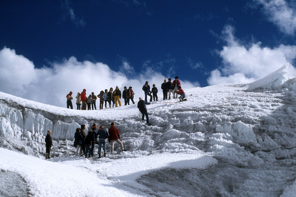
Visitors to Pastoruri Glacier.
About 18 km (11 miles) directly east of Huaraz at Pitec (3,800 m / 12,468 ft) is a fine hike to Laguna Churup (4,485 m / 14,715 ft). From Pitec, an obvious signed trail follows a ridge towards the lake, almost 4.5 km (3 miles ) away.
At some steep points, there are wooden steps or ladders, which are slippery when wet. The trail reaches a smooth, rocky shore overlooking the gorgeous lake under glaciated Nevado Churup (5,495 m / 18,029 ft) which makes a great lunch spot.
From Caraz, 66 km (41 miles) north of Huaraz, an unpaved road goes 30 km (19 miles) up a narrow gorge to Laguna Paron (4,140 m / 13,583 ft).
The lake is spectacularly surrounded by several peaks, including Caraz (6,025 m / 19,768 ft), Artesonraju, Pirámide (5,885 m / 19,309 ft), Chacraraju, Pisco, and Huandoy.
A trail follows the north shore of the lake, but many people just come for the views.
How to visit Huascaran National Park with PeruNorth:
Details of how to take a guided walk to many of the above destinations are provided on our Huaraz Day Hikes page.
And we offer a couple of classic, multi-day treks in the National Park:
If not wishing to hike at altitude, our Huaraz Cultural itinerary offers day visits to both Llanganuco and Pastoruri, as well as a drive over the Cordillera Blanca to get to Chavin de Huantar.
With so many outstanding destinations in the region, not all are described on the website … but we can certainly discuss the best way to visit. Just get in touch with any queries.
Tocllaraju Summit, Huascaran National Park.